Frequently Asked Questions
The following are frequently asked questions about MGP Xpress. Select any question to see its answer.
Use the Add Area tool to add an area in the location where you want to see imagery. After you add your area, you should see imagery products located within that area loading in the Search Results panel. Some images are automatically selected; these images load in the viewport.
See Adding Areas.
The images selected in the Search Results panel are low-resolution, so they will look a bit grainy or blurry. When you purchase an image, you will receive the high-resolution, sharper version of that image.
You can use a permalink to save the session you were working on to a permanent URL. This URL preserves your areas, selected images, and applied filters. You can send the permalink to users with or without a Discover account so they can view your session.
See Sharing Sessions.
When you want to order imagery over a certain location, you are prompted to draw an “Area” over that location. Then you have two choices: you can order images clipped to that area, or you can order full image strips.
If you order the images clipped to the area you drew or imported, that is considered ordering an area.
If you order the full image strips (not clipped to the area you drew or imported), that is considered an image purchase.
Yes! The glossary is built into our Online Help search. Search for a word or phrase. If the term is in the glossary, it will appear on the right-hand side of the search results. See Using the MGP Xpress Online Help.
Here are definitions for some common terms that you will encounter in MGP Xpress:
Image ID The 30-digit unique identifier for images in the online catalog, or the 16-digit unique identifier for images in the Maxar archive that are not online.
Cloud Cover The percentage of an image that is covered by clouds.
Off Nadir Angle The angle (in degrees) of a satellite in comparison to the location of the area on Earth captured by the satellite image.
Source The satellite from which an image was obtained (e.g., WorldView-3, GeoEye-1).
Ground Sample Distance (GSD) Resolution is determined by the ground sample distance (GSD). GSD is the maximum size (in meters) of one pixel on the ground. The lower the number, the more accurate (and sharper) the image will be.
To get a price quote for your selected products, sign in, add items to your cart, and submit the order inquiry form. A Maxar representative will contact you via email or phone with a quote and to help you place your order.
See Ordering Imagery.
The application is touch-enabled and work on any mobile device large enough to accommodate its functionality. This includes most tablets.
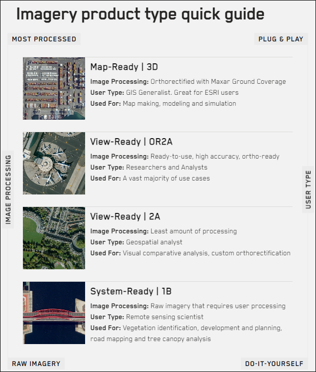
There are several imagery types available in MGP Xpress.
OR2A Our most popular image type! This is a high-quality satellite image that you can trust to be accurate and consistent when compared to other satellite images.
1B This is a basic and unprocessed satellite image that can be easily used with image processing systems, like photogrammetry. It has been adjusted to correct for any distortions caused by the angle of the satellite.
2A This is the best satellite image for viewing and analyzing features on the earth's surface. It has been processed with a coarse digital elevation model (DEM) to provide an accurate representation of the terrain.
3D This type of satellite image is orthorectified, which means it has been adjusted to correct for any distortions caused by the angle of the satellite. It is great for image viewing and locational reference, and it has a high degree of cartographic accuracy.
End User License Terms apply when our products and services are licensed directly from a Maxar Affiliate or through one of our authorized resellers.
For more information about licensing, please see https://www.maxar.com/legal.
For more help using MGP Xpress, visit our Online Help site: https://xpress-docs.maxar.com. You can also contact support using our support form.
For more information about each of these options, see Help.