Release Notes
Read the most recent release notes below
Looking for the developer guide release notes? Visit https://developers.vantor.com/docs/release-notes
Discover 1.2
These release notes include updates made in the 1.2 and 1.2.2 releases.
Capabilities
The following features are part of Discover 1.2:
Stereo Pairs
You can now search for and view stereo pair imagery in Discover. Stereo imagery products are designed for users with advanced image processing capabilities and photogrammetric tools. This product is ideal for Digital Elevation Model (DEM) generation, 3D visualization and feature extraction applications. Stereo images are collected in-track, meaning on the same orbit, and are acquired at angles optimal for stereo viewing and manipulation.
To view stereo pair imagery, draw an area. From the Product drop-down, select Stereo Imagery. If stereo imagery is available in your area, it will display in the Imagery panel.
Vivid Mosaic Imagery
You can now view and order Vivid Mosaic imagery in Discover. Vivid Mosaics is a suite of high-resolution, high-accuracy imagery basemap products, available off the shelf. From metro to global scale, Vivid Mosaics offer solutions to meet a range of customer needs and budgets.
To view Vivid Mosaic imagery, draw an area. From the Product drop-down, select the Vivid Mosaics product you want to view. If Vivid Mosaic imagery is available in your area, it will display in the Imagery panel.
Enhancements
The following enhancements have been added in version 1.2:
Apps Icon
If you have access to Discover, you can now use an Apps icon in the bottom-left corner of the Discover interface to quickly access other tools, such as the developer portal and Discover.
See Overview: Interface.
Area Cloud Cover
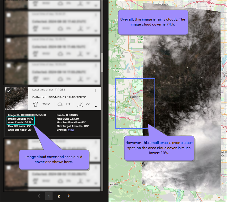
Area cloud cover is now the default cloud cover metadata value when viewing image results in the Imagery panel.
Area cloud cover indicates the amount of cloud cover for an image strip within the selected area, while image cloud cover indicates the amount of cloud cover over the entire image strip. Depending on the size of the area and the location of each image strip in the area, the area cloud cover and image cloud cover percentages for each image strip may be very different, or they may be identical.
In this example, the image cloud cover is only 13%, but the area cloud cover is 77%.
See Filtering Areas.
Export All Areas and Copy Area Details
You can now use Discover's area export tool to export all areas at once to a GeoJSON, KML, or a Shapefile. Exporting one or more areas lets you save your areas so you can upload them again at a future time, or share them with someone else.
You can also copy the details of a single area or all of your areas to the clipboard, and then paste them into another document or program. This functionality does not technically "export" the area(s), but it does allow you to easily copy details like the area name, catalog ID, and size to the clipboard.
See Exporting Areas.
Multiple Image ID Search
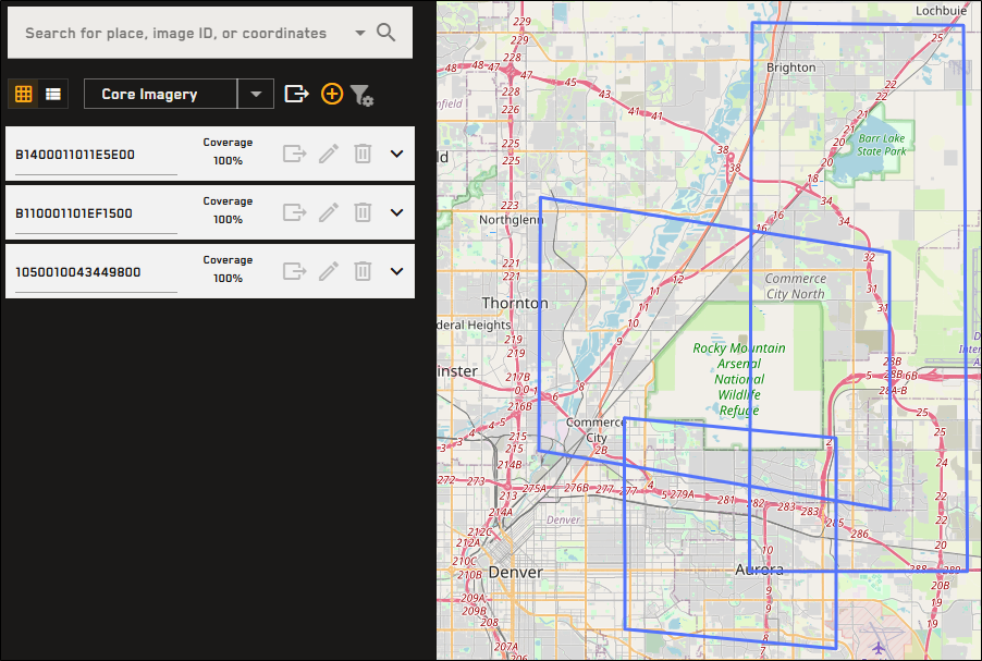
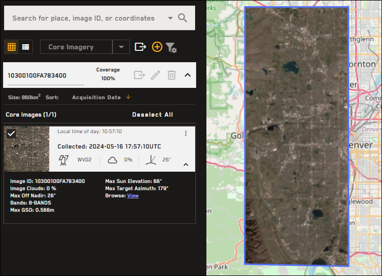
You can now search for multiple image IDs at the same time using the Imagery panel. If you search for one or more image IDs, and the image(s) is found, an area is drawn around the image(s) and it is added to the search results. Each found image is added as a separate area. Expand any area to view the image and its metadata.
Search for multiple image IDs using the Imagery panel to add each image as an area.
Expand the area to view the image and its metadata.
See Searching.
Open Data Enhancements
Enhancements have been made to the Open Data feature. The most notable enhancement is that all Open Data events are now visible without having to log in to Discover (however, you will need to log in to access event data). The subscription feature, which is no longer in use, has been replaced with social media icons. Some language clarifications make the Open Data feature easier to use and understand.
See Open Data.
Product Drop-Down
A Product drop-down has been added to the Imagery panel. The Product drop-down is a type of filter for the product categories that should display in the Imagery panel (e.g., core imagery, stereo imagery, Vivid Mosaic imagery). Core Imagery is selected by default. When changing product types, your filters and selected images are saved.
Deprecated Features
-
Vivid Premium imagery will be deprecated in the first half of 2024. As of this release, references to Vivid Premium have been removed from the Discover documentation.
-
Self-checkout has been deprecated. You can still place orders by manually submitting the order to Vantor. A Vantor representative will contact you with a quote and to help you place your order. See Ordering Imagery.
-
The order history page has been deprecated.
Documentation Updates
The following update has been made to the documentation in version 1.2.
-
A light mode/dark mode switcher is now available. To switch between viewing the documentation in light or dark mode, next to the Search bar, select Light/Dark Mode
 . Your browser remembers your preference.
Known Issues
The following are known issues in version 1.2:
-
If you use the special characters # _ & ^ ` : in the name or address field when self-registering, you will fail account security checks.
-
If you use a non-US postal code when self-registering, you must use correct formatting (e.g., adding a space for Canadian zip codes), or you will fail account security checks.
Discover 1.2.5 - 19 March 2025
Enhancements
The following enhancements have been added in version 1.2.5:
Local Time Filter
Local time filters have been added. Local time uses the image’s centroid as the reference. This is different from the time used in the Start/End Date filter, which uses collection time (based on UTC). See Filtering Areas.
Removed Feature
The following feature has been removed from version 1.2.5:
Vivid Advanced
Vivid Advanced has been removed.
Known Issues
The following is a known issue in version 1.2.5:
-
If you use the special characters # _ & ^ ` : in the name or address field when self-registering, you will fail account security checks.
Discover 1.2.6 - 16 July 2025
Enhancements
The following enhancements have been added in version 1.2.6:
Filter Updates
Several enhancements have been made to the filter functionality in Discover. These include:
-
Global Default Filters and Area Filters You can now create search filters globally as well as for individual areas.
-
Global Default Filters These settings are inherited by all areas, including any new areas that you create.
-
Area Filters These settings apply only to the selected area and override global default filter settings.
If you change area filter settings, global default filters are turned off. When you make new changes to the global default filters, the global default filter changes overwrite any area filters that you applied to individual areas.
-
-
High-Definition Eligible Imagery Only You can now filter your search results to only include high definition imagery.
When you select High-Definition Eligible Imagery Only, the available ranges for GSD, Area Off Nadir, and Sun Elevation automatically adjust to ensure the best possible imagery results.
-
GSD ≤60 cm (i.e., 70cm not available)
-
Area Off Nadir 0° – 30°
-
Sun Elevation 15° – 90°
Be sure to check your filter settings if you have previously made changes to these filters.
-
-
Ikonos Imagery Imagery from Ikonos-02 is now discoverable in Discover. When creating a filter, select this sensor from the Imagery Source drop-down.
-
Search by Catalog IDs Within an Area When adding an area-specific filter, you can now search by specific catalog ID(s) within the area.
See Filtering Areas.
Multiple Shapefile Import
You can now import ZIP files containing multiple shapefiles. These shapefiles will import as individual AOIs.
See Importing Areas.
Coordinate Entry for AOIs
You can now create a rectangular AOI using desired center point coordinates and specified length and width measurements.
See Adding Areas.
Known Issues
The following is a known issue in version 1.2.6:
-
If you use the special characters # _ & ^ ` : in the name or address field when self-registering, you will fail account security checks.
Discover 1.2.8 - 1 October 2025
MGP Pro is now Vantor Discover
MGP Pro has officially become Vantor Discover.
You will continue to have access to the same products and capabilities that you expect from this tool, but with a new visual look and feel. Your user credentials will remain the same, ensuring a seamless experience as we transition to this new branding.
Why the Change: Maxar has rebranded to Vantor, representing the culmination of our company’s multi-year journey to productize our core operational technology and transform from a satellite imagery and analytics provider into a software-driven spatial intelligence company. Learn more about that change here.
As part of that evolution, we’ve also updated our product architecture and branding. In addition to Vantor Discover, we’ve updated some naming for our imagery products. Our UIs and our technical documentation will reflect these new name changes. You can see all the updated names here.
Questions? Our new support email is support@vantor.com.
Discover 1.2.9 - 17 November 2025
Enhancements
The following enhancements have been added in version 1.2.9:
Area Upload: Simplified Geometries
Area upload now simplifies complex geometries. If an imported area has more than 1000 vertices, it is automatically simplified to comply with order standards (e.g., fewer than 1000 vertices, simple geometry, no holes, no duplicate vertices, no self-interections, no incomplete polygons, vertices >1m apart).
See Importing Areas.
Download and Export Enhancements
The following enhancements have been made to downloading/exporting imagery:
-
You can now export an area with or without the related metadata. If you export imagery metadata, it is included as a separate file in the ZIP file. See Exporting Areas.
-
If an area does not have 100% coverage, the unfulfilled portion of the area now displays in red. When you export an area that does not have 100% coverage, Discover automatically packages the unfulfilled portion of the area along with the complete area for reference. See Exporting Areas.
-
You can now save browse imagery to your computer. Right-click the browse link and select Save Link As... to save the browse image. See Overview: Imagery Panel.
Guest Login Flow Removal
You now must be logged in to access all functionality within Discover. Create a free account using a simple self-registration process, then use your new account to log in.
See Registering for an Account and Logging In and Logging Out.
Image Selection Enhancements
You can now easily view imagery collected within the last 72 hours. This allows you to easily see if new imagery has been collected over your areas of interest (AOIs).
Imagery Panel Redesign
The Imagery panel has been redesigned to provide a better user experience and more logical flow.
There are three main parts of the Imagery panel:
-
Search and Filters, where you can search for imagery, set default filters, and define the imagery type you want to view;
-
Your Areas List, where you can view your current areas and create new areas;
and
-
Area Imagery Results, an expanded panel where you can view imagery results for one area at a time. These results are visible as tiles or as a list.
Permalink Updates
Permalinks have been updated to support up to 100 AOIs and 50 images per AOI. Ordering of AOIs and names are preserved. When sending to SFDC/RCA, no more than 10 AOIs can be sent due to memory limitations.
See Sharing Sessions.
Documentation Updates
Due to the redesign of the Imagery panel, the following new topics have been added to the documentation in version 1.9.2. The information in these topics was previously included elsewhere in the documentation. Please update your bookmarks.
Known Issues
The following is a known issue in version 1.2.9:
-
If you use the special characters # _ & ^ ` : in the name or address field when self-registering, you will fail account security checks.


